

All you need to know about the 1,020MW Akosombo Hydro Electric Power Plant
Total Cost of Project (at the time of project completion) $196,000,000
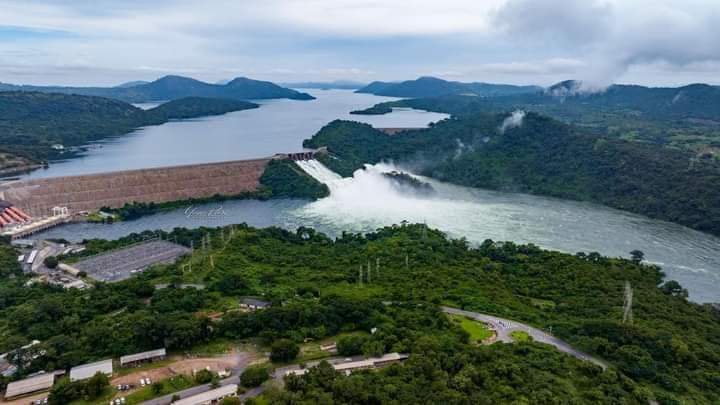
Dam Name: Akosombo Dam
Location: Akosombo
District: Asuogyaman District
Region: Eastern Region
Type of Dam: Rock fill Embankment Dam
Reservoir: Storage Reservoir
Water Course: Volta River
Length of main Dam at crest: 660m (2,165.33ft)
Length of Saddle Dam: 355m (1, 164.68ft)
Axis from Bedrock: 111m (364. 17ft)
Net Generation: 6, 502, 784,456 kwh
Height at axis from bedrock: 111m (364.17ft)
Area of Lake: 8,502sq.km
Capacity of Lake: 148 x 10 12 litres
Shoreline: 7,250km
Length of Lake: 400km
Original Constructions: 1961 – 1965
Structural Height: 375ft
Hydraulic Height :(Normal operating Depth at Dam) 68.8 metres (226 ft.)
Top parapet (Elevation): 290ft
Spillway Crest Elevation: 236ft
Crest Elevation: 236ft
Crest Length: 640m (2,100ft)
Crest Width: 40ft
Base Width: 366 meters (1,201 ft)
Volume of Dam Construction Materials: 7,943,520m3 (26,061,100.42ft)
Main Dam Axis: N 89° 05″ 18″ E
Saddle Dam Axis: S 54: 30″ 04″ E
Top of Exclusive Flood control Pool (Elevation): 278ft
Reservoir Capacity: 120,000,000 acre feet
Hydraulics
The Akosombo Dam has 640m crest length and 141m high. Two spillway structures are constructed in concrete and founded on rock. The two gated structures include in total 12 identical gates (6 gates at each spillway, dimensions W x H= 11.73m x 12.19m). The two spillways are adjacent to each other but the spillway chutes are pointing in slightly different directions.
The gates are operated by one single moveable hoist (same hoist used on both spillways). The 335m crest length and 37m high Saddle Dam located about 1km east of the main Dam is constructed as a rock fill embankment Dam with central core of clayey materials. The Saddle Dam is founded on rock and the foundation level is well above the tail water level.
Total water Storage at Elevation 84.73 metres (278.0 ft.)
Maximum Water Surface Elevation Concrete lined, Rock founded, Six twin
Spillway Type Gated Spillway Structure
Spillway Capacity at Elevation Drainage Area 34,000 m3/s (1,200,000 cu ft/s)
Drainage Area 6500 sq km
Probable Maximum Flood (PMF) (Inflow) 32,042 m3/s
Probable Maximum Flood (PMF) (Outflow) 23,010 m3/s
Maximum Operating Level 84.73m (278ft)
Minimum Operating Level 73.15m (240ft)
Maximum Water Level ever recorded 84.59m (277.54ft) on 8th November, 2010
Minimum Water Level ever recorded 71.62m (234.96ft) on 21st July, 2007
Maximum Annual Inflow ever recorded 62.09 MAF in 1968
Minimum Annual Inflow ever recorded 6.20 MAF in 1983
Turbine
Unit output -173.1MW (222000hp) (Retrotted Units)
Head (Max) -68.88m (226ft)
Synchronous speed – 115.4 Rev/Min
Type of Turbine -Francis, Vertical shaft
Manufacturer -VA Tech, Voest Alpine, Austria
Generator
Rating -179.5MVA at 14.4KV, 0.95PF Manufacturer -General Electric, Canada
Exciter
Type – Static (SILCO-5) Manufacturer -General Electric, Canada
Unit Transformer
Type – Outdoor 3phase Rating -200/MVA, 14.4/161KV Cooling -OFAF Manufacturer -Areva, Turkey
Governor
Type -Digital/Hydraulic Manufacturer -Andritz Hydro, Austria
Penstock
Type -Steel, one per unit Diameter 7.2m (24ft)
Maximum Water Surface Elevation Concrete lined, Rock founded, Six twin
Funding
Financial Support:
International Bank for Reconstruction & Development
$ 47,000,000
United Kingdom Government
$ 14,000,000
Export & Import (Exim) Bank
$ 10,000,000
United States (US) Aid
$ 27,000,000
Ghana Government
$ 98,000,000
Total Cost of Project (at the time of project completion) $196,000,000


Source: Yaw Premo || Abasem TV